
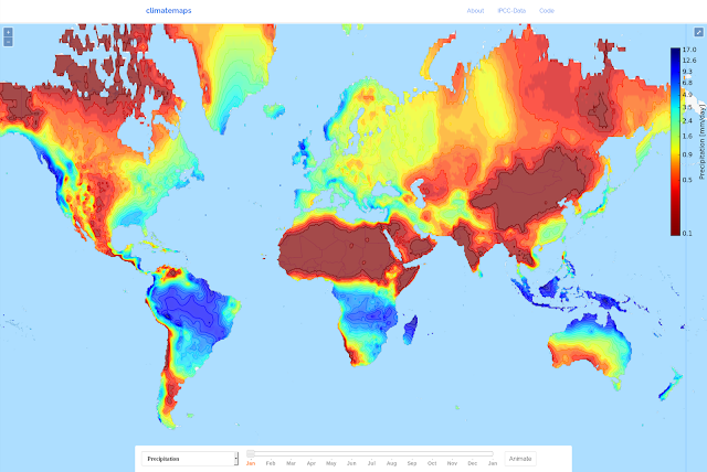
"Climatemaps visualizes the weather over the course of a year around the whole world. The map animates average global monthly climate data from 1961-1990 to show you when every location in the world has its hottest, driest or wettest weather." - http://googlemapsmania.blogspot.nl/2016/08/annual-weather-patterns.html#links
11 comments:
Also mentoined here: http://www.vividmaps.com/2016/08/climate-maps.html
And now also on the 'I Fucking Love Maps' Facebook page: https://www.facebook.com/EgoStupriAmoreMaps/?hc_ref=PAGES_TIMELINE&fref=nf
Nice.
Also a nice item for: https://www.reddit.com/r/dataisbeautiful
I posted it at r/dataisbeautiful, did not really get of the ground, but it is how these map related blogs found out about it. More than 1000 visitors yesterday. And some nice emails from map fanatics :)
Another mention: http://rilos.ru/en/blog/393-how-is-the-weather-always-and-everywhere
And here: http://www.tysmagazine.com/climatemaps-visualiza-tiempo-ano/
Nice
And here: http://www.geopalavras.pt/2016/09/isolinhas.html?m=1
And also here: http://mapcruzin.blogspot.nl/2016/09/open-source-climate-maps-using-ipcc-data.html
And here http://geolink.jp/blog-entry-1535.html.
your map is going places!
Post a Comment