
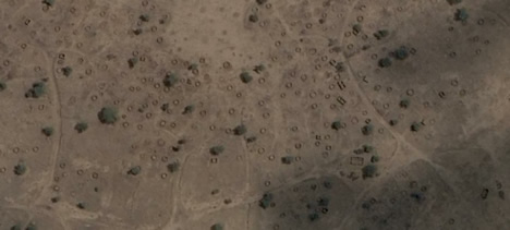
 "Those circles aren't animal pens. They're burned-down gottias, circular mud huts that had straw roofs, and they're what's left of Dalia, a village in Sudan's Darfur region, one of hundreds of villages that have been destroyed by the Janjaweed in a program of depopulation that has killed perhaps 400,000 civilians since 2003.
I used pointers from one draft version to highlight 15 of the destroyed villages visible in the imagery released today. Here it is, Google Earth KMZ file. Zoom in close. This is just a minuscule subset of the devastation in Darfur."
"Those circles aren't animal pens. They're burned-down gottias, circular mud huts that had straw roofs, and they're what's left of Dalia, a village in Sudan's Darfur region, one of hundreds of villages that have been destroyed by the Janjaweed in a program of depopulation that has killed perhaps 400,000 civilians since 2003.
I used pointers from one draft version to highlight 15 of the destroyed villages visible in the imagery released today. Here it is, Google Earth KMZ file. Zoom in close. This is just a minuscule subset of the devastation in Darfur."
2 comments:
interesting map!
Your kmz file is indeed just a minor subset of the devastation.
Too bad the petition urges both the UN and George W. Bush.
Very tragic... This also sends such a bad message to the rest of the world, i.e. that you can still get away with genocide in this day and age.
If you turn on the "Google Earth Community" layer, you can also see the places where many other villages were destroyed or abandoned (every I on the map). See map.
That petition seem to be only for Americans.
I've already donated some money to "Stichting Vluchteling", but I wish there was some institution that you could pay to recruit a couple of thousand troops and really make a difference.
Post a Comment